Land preparation is where precision farming begins.
A well-leveled field improves water distribution, supports uniform crop growth, reduces rework, and sets up every operation that follows.
Why Land Preparation Matters?
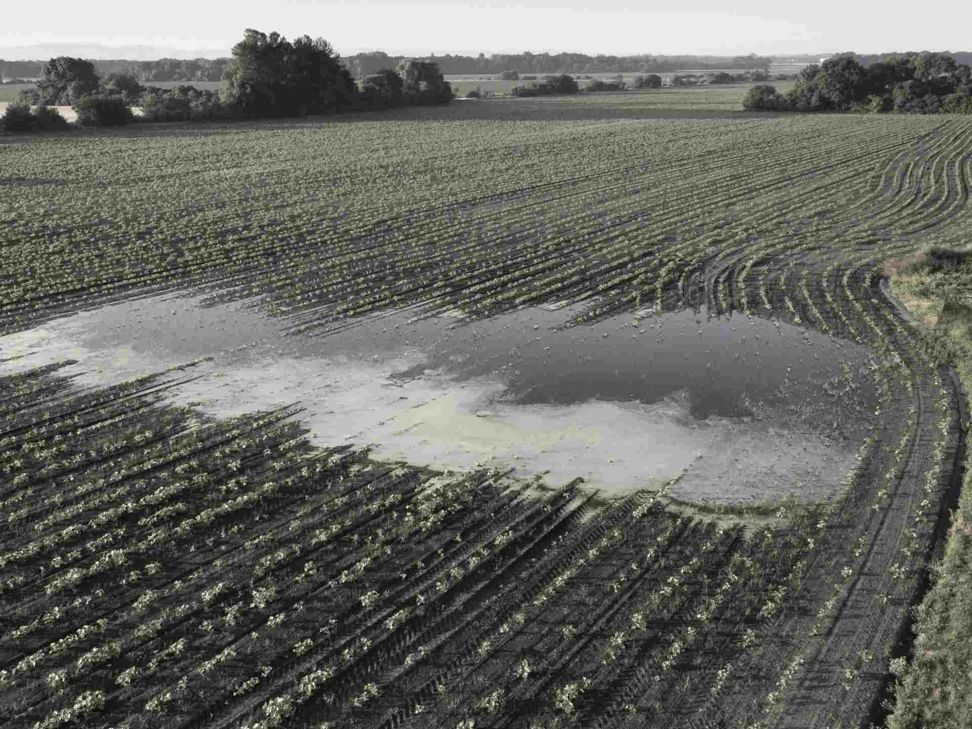
Uneven Fields Cost You All Season
High spots dry out too quickly. Low spots collect water. Uneven surfaces lead to inconsistent irrigation, fertilizer loss, poor crop uniformity, operator fatigue, and repeated fieldwork. Before planting begins, land preparation gives farmers the chance to fix the field surface and improve every operation that follows.


Find the Right Land Leveling System for Your Field

FJD AL02
GNSS Land Leveling System
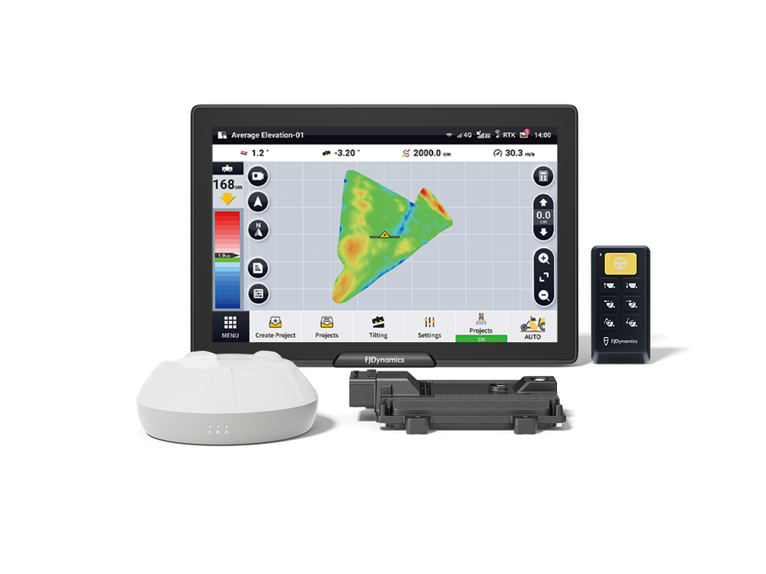
FJD AL02 Max
Advanced GNSS Land Leveling System
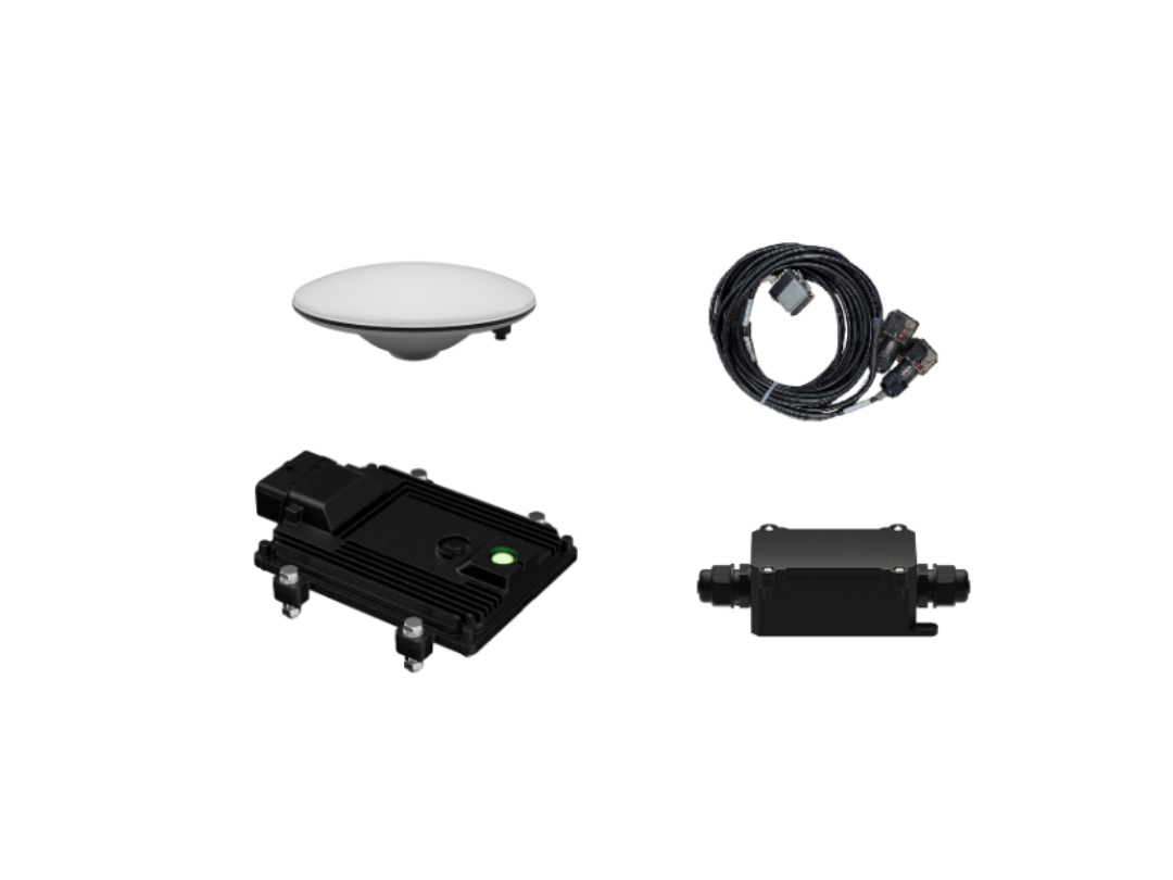
Add-on Package
For compatible FJD Autosteering Systems
10″
Display
12″
Display
10″ - 12″
Display
*Depending on the paired FJD Autosteering System.
Single & Dual Slope
Slope Modes
Single & Dual Slope
Slope Modes
Single & Dual Slope
Slope Modes
Paddy & Dryland
Terrain Compatibility
Paddy & Dryland
Terrain Compatibility
Paddy & Dryland
Terrain Compatibility
Supported
Multi-Machine Collab
Supported
Multi-Machine Collab
Supported
Multi-Machine Collab
Supported
Pause & Resume
Supported
Pause & Resume
Supported
Pause & Resume
Supported
Import Design File
Supported
Import Design File
Supported
Import Design File
GNSS-Based Leveling
Work beyond laser limitations with high-precision GNSS positioning and automatic blade control.
Minimal Earth-Moving
Use terrain data to reduce unnecessary cut-and-fill, saving time, fuel, and soil disturbance.
Level, Single-Slope & Double-Slope Design
Support level, single-slope, and double-slope designs for paddy and dryland fields, adapting to different irrigation and drainage needs.
Collaborative Projects & Records
Import design files, coordinate multiple machines, and sync progress in real time with the FJD Land Leveling Solution — with pause-and-resume support and project records for review and reporting.
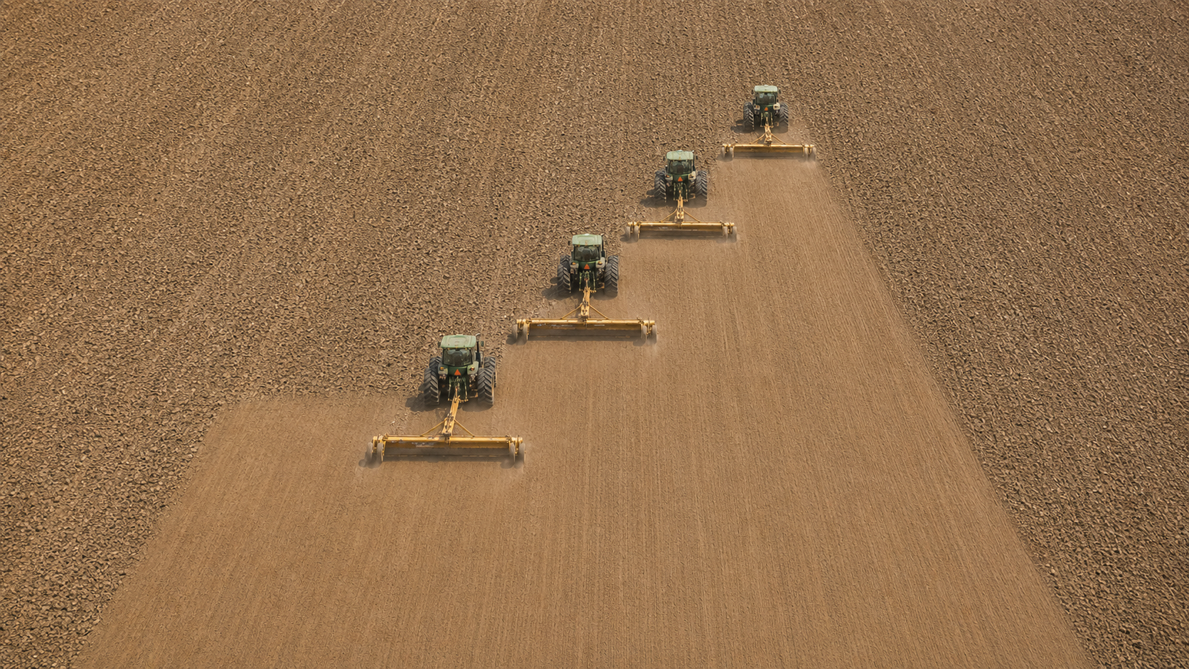
Level Smarter. Save More Across the Season.
By improving field surface consistency and automating blade control, FJD AL02 helps farms reduce water waste, fuel consumption, and repeated passes.
0%
Water Saving
Improved irrigation uniformity across the field
0%
Fuel Reduction
Fewer repeated passes and less rework
0%
Efficiency Boost
Faster completion with automated blade control
*Results may vary by field condition, equipment setup, crop type, and operation practice.
How to Get Started?
Choose the workflow that fits your operation.


Precision starts here. Before entering the field, make sure your guidance system has the right positioning signal. StellarFusion gives you multiple correction options — from local RTK base station to global StarNav — so you get consistent sub-inch accuracy whether you are on a single farm or moving across fields in different regions.
Not sure which signal to choose? Use our Signal SelectorCollect boundary and elevation data to understand the field surface.
Choose level ground, single-slope, or double-slope design based on irrigation and drainage needs.
Complete height calibration so the system can control the blade accurately.
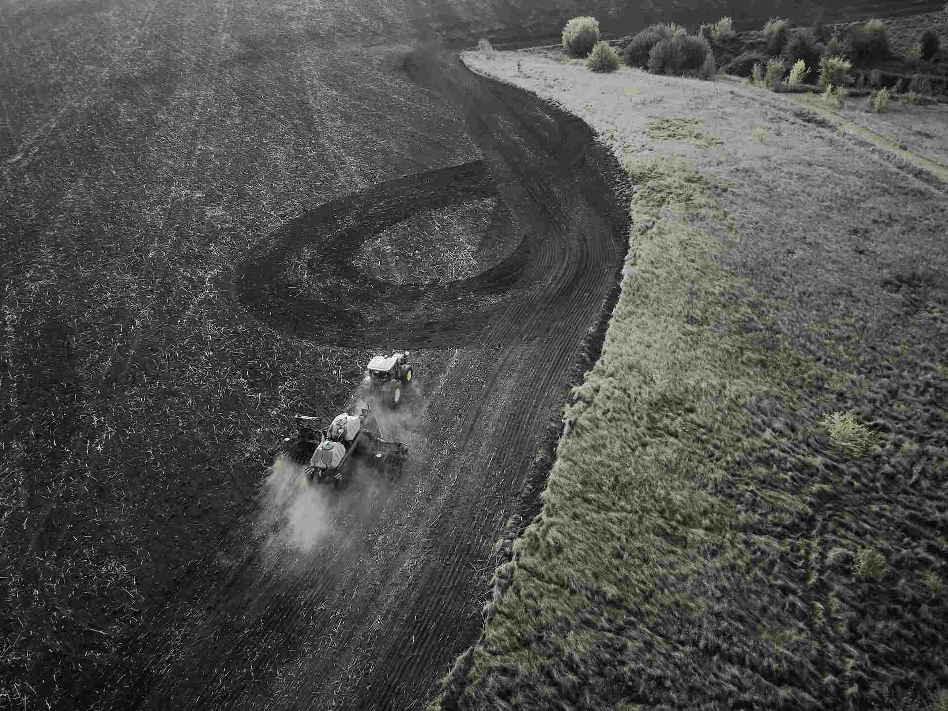
FJD AL02 automatically controls the blade to cut and fill according to the design.
FieldFusion manage project files, share designs, monitor progress, review completed work, and turn leveling data into a foundation for future planting, irrigation, and crop management decisions.
Collect terrain data with AL02, an RTK-equipped ATV, handheld RTK receiver, or drone-based survey workflow where supported.
Export survey data and create a land-forming design in professional software such as OptiSurface or EziGrade.
Import the supported design file into the FJD terminal or upload the project through FieldFusion for operators and machines.
AL02 / AL02 Max controls blade height and tilt based on the design, helping reduce rework and improve leveling consistency.
Sync project data with FieldFusion to review completed work, manage records, and guide future field preparation.
Land preparation is where precision farming begins.
A well-leveled field improves water distribution, supports uniform crop growth, reduces rework, and sets up every operation that follows.
Why Land Preparation Matters?
Uneven Fields Cost You All Season
High spots dry out too quickly. Low spots collect water. Uneven surfaces lead to inconsistent irrigation, fertilizer loss, poor crop uniformity, operator fatigue, and repeated fieldwork. Before planting begins, land preparation gives farmers the chance to fix the field surface and improve every operation that follows.
Find the Right Land Leveling System for Your Field
FJD AL02
GNSS Land Leveling System
FJD AL02 Max
Advanced GNSS Land Leveling System
Add-on Package
For compatible FJD Autosteering Systems
10″
Display
12″
Display
10″ - 12″
Display
*Depending on the paired FJD Autosteering System.
Single & Dual Slope
Slope Modes
Single & Dual Slope
Slope Modes
Single & Dual Slope
Slope Modes
Paddy & Dryland
Terrain Compatibility
Paddy & Dryland
Terrain Compatibility
Paddy & Dryland
Terrain Compatibility
Supported
Multi-Machine Collab
Supported
Multi-Machine Collab
Supported
Multi-Machine Collab
Supported
Pause & Resume
Supported
Pause & Resume
Supported
Pause & Resume
Supported
Import Design File
Supported
Import Design File
Supported
Import Design File
GNSS-Based Leveling
Work beyond laser limitations with high-precision GNSS positioning and automatic blade control.
Minimal Earth-Moving
Use terrain data to reduce unnecessary cut-and-fill, saving time, fuel, and soil disturbance.
Level, Single-Slope & Double-Slope Design
Support level, single-slope, and double-slope designs for paddy and dryland fields, adapting to different irrigation and drainage needs.
Collaborative Projects & Records
Import design files, coordinate multiple machines, and sync progress in real time with the FJD Land Leveling Solution — with pause-and-resume support and project records for review and reporting.
Level Smarter. Save More Across the Season.
By improving field surface consistency and automating blade control, FJD AL02 helps farms reduce water waste, fuel consumption, and repeated passes.
0%
Water Saving
Improved irrigation uniformity across the field
0%
Fuel Reduction
Fewer repeated passes and less rework
0%
Efficiency Boost
Faster completion with automated blade control
*Results may vary by field condition, equipment setup, crop type, and operation practice.
How to Get Started?
Choose the workflow that fits your operation.
Precision starts here. Before entering the field, make sure your guidance system has the right positioning signal. StellarFusion gives you multiple correction options — from local RTK base station to global StarNav — so you get consistent sub-inch accuracy whether you are on a single farm or moving across fields in different regions.
Not sure which signal to choose? Use our Signal SelectorCollect boundary and elevation data to understand the field surface.
Choose level ground, single-slope, or double-slope design based on irrigation and drainage needs.
Complete height calibration so the system can control the blade accurately.
FJD AL02 automatically controls the blade to cut and fill according to the design.
FieldFusion manage project files, share designs, monitor progress, review completed work, and turn leveling data into a foundation for future planting, irrigation, and crop management decisions.
Collect terrain data with AL02, an RTK-equipped ATV, handheld RTK receiver, or drone-based survey workflow where supported.
Export survey data and create a land-forming design in professional software such as OptiSurface or EziGrade.
Import the supported design file into the FJD terminal or upload the project through FieldFusion for operators and machines.
AL02 / AL02 Max controls blade height and tilt based on the design, helping reduce rework and improve leveling consistency.
Sync project data with FieldFusion to review completed work, manage records, and guide future field preparation.
Hear It from Our Customers
Greenkeeper, Black Water Links Golf Course
"I think robot at the golf course is a game changer for our profession."
Head Coach, Lüdenscheid Lightnings
"You only need to set it up, feed it some paint, and then you can sit back and enjoy watching it mark the field."
1.02M Followers
"Even on slopes, in thick grass, and with intentional obstacles, we’ve had no issues at all."
Ready to Level Your Fields with Precision?
Talk to our team to find the right solution for your land preparation needs.